


Presented by Satellite Educators Association
And Sponsored by

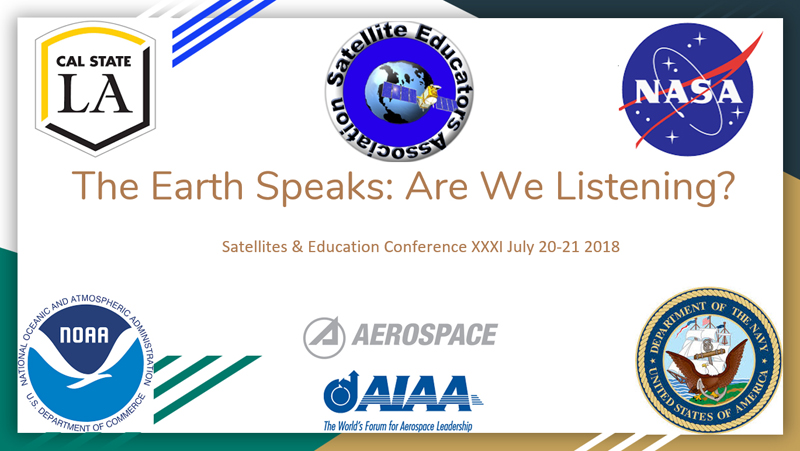
"Satellites & Education Conference XXXI at Cal State LA July 2018"
"Heat Island Effects: The 2018 M.Y. S.P.A.C.E. Research Report"

STEM - an acronym meaning Science - Technology - Engineering - Mathematics. The original term was SMET standing for "science, mathematics, engineering and technology" but was changed to STEM ("science, technology, engineering, mathematics") for a more pleasant soundig acronym. Why is STEM important?
By its very nature, scientific investigation includes both qualitative an quantitative observations and thinking. The Satellite Educators Association believes that educational situations in which all teachers - especially teachers of science, mathematics, engineering and technology - collaborate to support student learning and development is best. Science and math teachers working together allow math classes to prepare students for the specific math applications they will need in their science classes and enable science teachers to present opportunities for students to apply those math skills. Then when science and math teachers fold-in the design and assessment components of engineering and technology, there will be a truly systemic integration of STEM.
Science teachers who really engage their students in scientific inquiry cannot do so without inclusion of quantitative considerations at some level. Math teachers who talk with science teachers discover ways for students to apply their math skills immediately in their science classes. Collaboration is not difficult.
When students view science and engineering and technology together with math as interconnecting rooms of the same house instead of unrelated subjects compartmentalized into different houses, they, too, can comprehend STEM integration through experience and beyond mere definition.
The 31st annual Satellites & Education Conference, held July 20-21, 2018 at California State University, Los Angeles, presented teachers with bountiful opportunities to discover integrating STEM learning using satellite technologies in studying our planet home. Teachers of science, math, language arts, geography, engineering, and technology and students from middle school through and post-graduate levels gathered together to learn from each other and explore rich experiences together.
This Conference hosted some very special and informative keynote speakers.
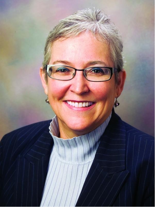
Cheryl Ney earned her Ph.D. in biochemistry from the University of Chicago, her M.S. in chemistry from Baylor University, and her B.S. in chemistry from Arizona State University. She has served as a professor of chemistry, associate provost, associate vice president, and National Science Foundation Distinguished Visiting Professor of Women in Science in the University of Wisconsin system. January 2017 she was named Dean of the Charter College of Education (CCOE). Cal State LA's CCOE was the first charter college in the nation and operates with faculty, staff, students, and community collaborating in a shared governance structure. Dr. Ney is a strong advocate for a diverse workforce of STEM professionals placing strong emphasis on career and technical education and STEM outreach. She has been an avid supporter of this conference, and SEA was honored when she spoke at the opening of this 31st annual Satellites & Education Conference.
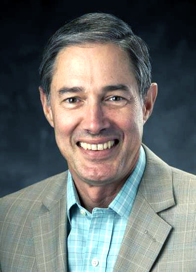
Bob Friend is chief engineer of space systems for Phantom Works, a business within Boeing Defense, Space & Security (BDS). In this capacity, he oversees the technical integrity and engineering execution of all organizational space products and programs. Friend ensures technological development supports future business and technology plans across BDS. He also leverages external development efforts to integrate Boeing products.
Prior to this position, Friend held chief engineering roles for advanced space and intelligence systems, and small satellite programs, where he developed spacecraft designs, avionics, software, and demonstrated autonomous satellite refueling.
Friend began his 31-year aerospace career with Rockwell Aerospace and Defense, which was later acquired by The Boeing Company. During that time, he held a variety of program management and engineering roles of increasing responsibility. He was also one of two U.S. engineers selected to incorporate engineering into the national Next Generation Science Standards which was published in 2013.
Friend holds a bachelor’s degree in aerospace engineering from Northrop University, and is an Americian Institute of Aeronautics and Astronautics (AIAA) associate fellow.
Friend's informative talk focused on educational aspects of AIAA.
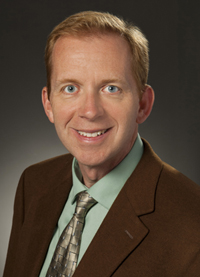
John Bloomer is an Engineering Fellow with over 19 years of experience in aerospace engineering and system architecture at Raytheon. Dr. Bloomer has worked on a variety of space and airborne EO sensor systems, across mission areas including missile defense; scientific earth imaging; intelligence, surveillance and reconnaissance; and space situational awareness. He has spent much of his career specializing in performance analysis and algorithm development at the “front end” of the business, working on original concept definition, business capture, and detailed system design. He served as Raytheon Corporate Technology Area Director for electro-optical systems, tracking enabling electro-optical technologies across all four major business units within Raytheon, sponsoring innovation and R&D activities, and fostering cross-business unit collaboration. He was one of the first 60 Raytheon Certified Architects in the worldwide corporation, and regularly functions as a lead engineer and technologist on key development projects. Dr. Bloomer holds a B.A. in Physics from Wabash College and a Ph.D. in Physics & Astronomy from the University of Rochester.
Speaking at the annual SEA Banquet, Dr. Bloomer presented his perspective on motivation for studying and working in science and technology fields. He drew on his educational trajectory from liberal arts through astronomical research, professional experience working in space system and technology development at Raytheon, and insights gleaned from small space entrepreneurs and futurists.
Joseph Lucey graduated with a Bachelor of Science in Civil Engineering from Cal State LA in June and proceeded to doctoral studies at the University of California, Los Angeles. His senior project: "Modeling Surface Water Inundation Using NASA Remote Sensing Data Products." Lucey describes his project and its importance. "Floods annually cause several weather-related fatalitites and financial loasses. According to NOAA and FEMA, there were 43 deaths and 18 billion dollars paid out in flood insurance policies during 2005. The goal of this work is to improve flood prediction and flood risk assessment by creating a general model of various NASA products. Using satellite-based flood inundation obervations, we can relate surface water formation processes to changes in other hydrological variables, such as precipitation and ground water storage, and understand how runoff generation response to there forcings is modulated by local topography and land cover. Using ground water storage observations (GRACE), precipitation (GPCP), land use (MODIS), topographic related variables (HYDRO1K) and surface inundation levels (SWAMPS), an assessment of geological and climate conditions can be performed for any location around the world. This project utilizes multiple linear regression analysis evaluating the relationship between surface water inundation, total water storage anomalies and precipitation values to determine their statisical relationships and influences on inundation data. This research demonstrates the potential benefits of using global data products for early flood prediction and will improve our understanding of runoff generation processes."
Mr. Lucey focused particular attention on the M.Y. S.P.A.C.E. students and teachers in the audience as he included steps in preparing his research poster and research design. His presentation was very well received and appreciated.
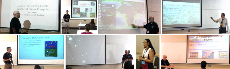
Ten plenary and concurrent sessions spanning two days were offered at Satellites & Education Conference XXXI in support of teacher professional learning.
Plenary Sessions
Concurrent Session presenters and topics included:
The Exhibit Hall offered exciting, informative, and interactive stations providing information, teaching materials and support from these friendly and helpful exhibitors:
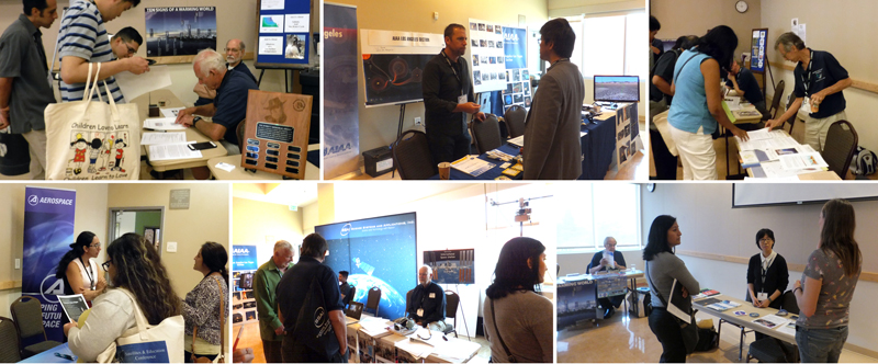
Many thanks to all who contributed unwavering support for teachers and STEM education.
A special word of thanks to the conference staff... These gracious volunteers are largely responsible for the success and longevity of this conference," said Dr. Paula Arvedson of Cal State LA and Satellites & Education Conference Coordinator. The conference staff was visible during the conference and worked tirelessly behind the scenes. Special thanks to Volunteer Coordinator Paul London for organizing the staff composed of teachers or teachers-in-training from the Charter College of Education at Cal State LA and other volunteers.
The Satellite Educators Association (SEA), producer of the conference, was founded in 1989 in response to an overwhelmingly positive turn out for the first Satellites & Education Conference. It is a non profit 501(c)(3), professional organization of educators and others who want to enhance the education environment to excite students about science, technology, engineering, and math (STEM) through space-based technology - satellites and satellite data. Association activities include professional development for teachers, especially the annual Satellites & Education Conference, the international Multinational Youth Studying Practical Applications of Climatic Events (M.Y. S.P.A.C.E.) research collaborative for K-12 students (including M.Y. S.P.A.C.E. Teacher training and year-round support), the online SEA Lesson Plan Library, and the almost-monthly SEA Newsletter online. SEA members have assisted in full or supplemental curriculum development to meet the needs of specific state standards, learning groups, and classrooms on request; promoted public outreach; and consulted with aerospace businesses in meeting their educational outreach requirements. The Conference and the M.Y. S.P.A.C.E. Program are supported by SEA members, the U.S. Navy, NOAA (especially NESDIS and NWS), NASA, and Cal State LA especially its Charter College of Education.
For more about this and other conferences and activities of the Satellite Educators Association, visit Conferences at http://SatEd.org.
Photo Credits: Satellite Educators Association
by Pete Arvedson, M.Y. S.P.A.C.E. Program PI, Satellite Educators Association
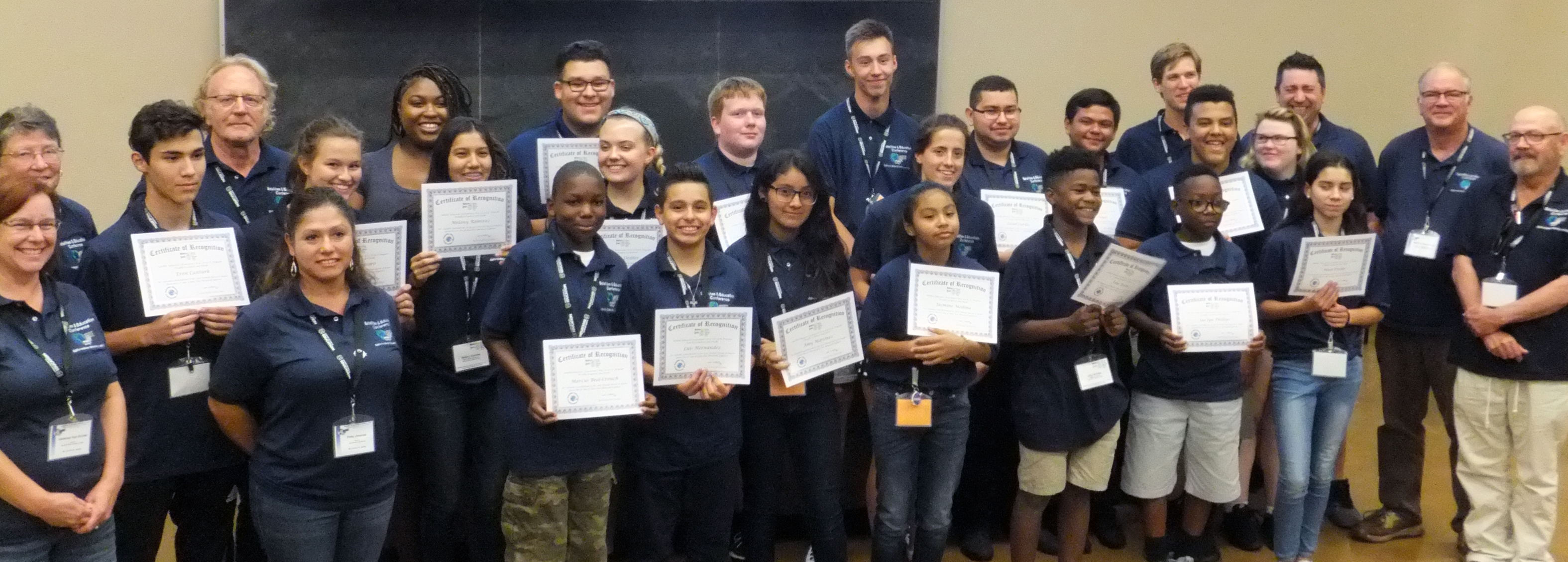
The 2018 M.Y. S.P.A.C.E. Team investigated local impacts of heat island effects. Local student research groups from Southern California, New Jersey, and the United Kingdom conducted research throughout the year on impacts important to their individual school locales. Student delegates from each local research group came together at the annual M.Y. S.P.A.C.E. Team Meeting July 17 to 21, 2018 to share data, discover common threads in their local investigations, formulate a global perspective supported by their local data, and deliver their overall report at the closing session of Satellites & Education Conference XXXI on Saturday, July 21.
The report of research, titled Earth Speaks: Are We Listening?, began by defining the global warming problem with an overview of ten signs of global warming listed by NOAA: increasing ocean heat content, air temperatiure over the ocean, sea surface temperature, global sea level, humidity, air temperature over land, and temperature of the lower atmospher; additionally, decreasing Arctic sea ice, less snow, and receding glaciers -- all signs of a warming world. These were followed by a concrete definition of "heat islands" and the "heat island effect." Urban heat islands are typically urbanized areas with surfaces that absorb heat including concrete and asphalt. The absorbed sunlight energy is re-radiated as infrared -- heat. Developed urban areas tend to have higher temperatures than the surrounding, less-developed countryside.
"Why should we care?" That was the question posed by the Team, and they answered it with four related areas from their individual investigations: other factors contributing to urban heat island effects, health, vegetation, and economic impacts.
Health issues included heat related ailments and artificial turf installed in school athletic fields. There was a correlation between a continuous fifty year increase in the "urban sprawl" of Philadelphia and the number of heat related incidents treated at local hospitals. Then, not only did the students' local measurements show artificial turf absorbed sunlight to temperatures reaching 120°F (more than 30° higher than grass fields), but the injuries cased by sliding bare knees, legs, arms, and hands across artificial turf were significant higher.
Greater amounts of vegetation in urban areas were investigated as approaches to mitigating higher urban temperatures. Green roofs, increasing green fields around built-up areas, and planting more trees throughout urban landsacpes all showed some lowering of the higher temperatures associated with the urban heat islands. The "greening" of urban areas inferred reduced energy use, improved air quality and lower greenhouse gas emissions, and an overall improved quality of life.
The Team investigated several interrelated economic effects of urban heat islands including drought and water usage, agriculture and water usage, and increased demand for electricity as more people move into urban settings. Looking at California as a example, vegetation in the state (as detected by satellite remote sensing) visibly decreased between 1988 and 2018. Much of that decrease was blamed on long-term drought and dwindling water reserves. Much of that decrease was in California's great central valley, historically an agriculturally rich region. Less green translates to fewer crops affecting the agricultural economy of the state. Then as more people move into urban settings and out of rural areas, the demand for electricity is increased. About 15% of electricity usage and cost is consumed by space cooling.
Even with the mitigations suggested by greening efforts in urban areas, the Team's research did not paint a pretty picture overall. More education is needed with more people caring about the larger environment for everyone. The presentation concluded with another question,"Are you listening now?"
Each student research group used both locally generated measurements and satellite-based temperature determinations. The most often used satellite-bsed data was the thermal infrared bands (Bands 10-11) from instruments on Landsat 8. Imagery was obtained from USGS online, processed for analysis and interpretation with ImageJ and MultiSpec, and pixel value of individual pixels translated to Celsius temperature using equations published by the USGS.
Participating in the 2018 M.Y. S.P.A.C.E. Team were students from these schools:
The M.Y. S.P.A.C.E. Report of Research for 2018 was presented by this team of students to the closing session of Satellites & Education Conference XXXI on Saturday afternoon, July 21, 2018. However, Friday evening, July 20, before the annual SEA Banquet and Awards Program, individual school research groups presented their research posters during the pre-banquet reception. Every member of every student group interacted with a constantly rotating audience, answering questions, and explaining their individual group projects with enthusiasm and ease.
Many thanks to all who contributed to the the 2018 research project. First and foremost, the M.Y. S.P.A.C.E. Teachers mentioned above who received training then worked with the students at their school sites throughout the school year. Special thanks to those who made it work at the conference: SEA President Mark McKay who guided the student delegates to their final report; Michael Holst who coordinated all student activities; Dr. Steve LaDochy, Dr. Paula Arvedson, and Dr. Hong-lie Qiu of Cal State LA who offered instruction and guidance to the Team in urban heat islands, methods for determining common threads in diverse reports, and use of ArcGIS, respectively; Annie Richardson, our tireless and supportive host at NASA Jet Propulsion Laboratory; and Pete Arvedson, the MY. S.P.A.C.E. Program PI.
Photo Credits: Satellite Educators Association, Inc.
Find out more about the M.Y. S.P.A.C.E. Program here